The Defence Research and Development Organization’s (DRDO) Pralay quasi-ballistic missile system will incorporate MicroGenesis TechSoft Pvt. Ltd.’s INDIGIS geospatial platform, marking a significant milestone.
Real-time mission planning and launcher visualization will be made easier by this connection, highlighting India’s efforts to become technologically independent in defense software.
Missile battery commanders now have a safe, offline-capable digital mapping environment thanks to the deliberate selection of INDIGIS. Launcher locations, missile kinds, real-time range rings, no-escape zones, and other crucial geographical data can all be visualized with its help. For accurate mission planning in high-stakes operations, such talents are essential.
This solution satisfies DRDO’s mandate for a fully indigenous, sovereign system by replacing previously licensed foreign GIS engines. INDIGIS strengthens national security in critical defense applications and reduces cybersecurity threats by removing external dependencies.
INDIGIS, which was first created by DRDO’s Center for Artificial Intelligence and Robotics (CAIR), was given to MicroGenesis through a commercial technology transfer agreement. The platform was then customized by MicroGenesis to satisfy the unique operational requirements of the Pralay system, exhibiting a smooth partnership between public research and commercial industry.
MicroGenesis TechSoft Pvt. Ltd.’s Managing Director, Manoj Tharian, was pleased that the platform was chosen for this crucial position. He emphasized the wider ramifications for domestic innovation by saying, “This selection reflects not only our engineering excellence but also India’s growing capability to innovate sovereign defense technologies.”
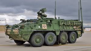
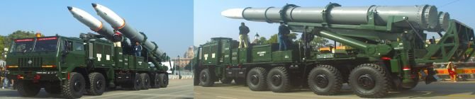
A prime example of Indian defense engineering is the Pralay missile. This domestic solid-propellant, short-range quasi-ballistic missile has a range of roughly 150 to 500 km and is designed for high-precision conventional strikes.
Pralay has successfully completed several flight tests and is outfitted with cutting-edge navigation technologies. It would strengthen operational superiority and provide tactical deterrence against regional threats when it is inducted into the Indian Armed Forces.
One unique high-performance Geographic Information System (GIS) platform is INDIGIS, which is entirely indigenous. It tackles the challenges of strategic and defense contexts and was designed by CAIR for mission-critical, secure, and offline-capable geospatial applications.
Real-time mission planning, spatial analytics, visualization, and decision support are some of INDIGIS’s key features. Sovereignty, security, and scalability are given top priority in its design, cutting off dependence on foreign GIS engines and increasing India’s independence in vital digital infrastructure.
The platform, which offers trustworthy geospatial intelligence, has been implemented in numerous defense and strategic initiatives. In operations where accuracy can decide results, this guarantees accuracy and reliability.
The platform’s commercial steward, MicroGenesis, is a top digital transformation company. With over 20 years of experience, it enables businesses all over the world to increase operational effectiveness, promote growth, and encourage innovation.
MicroGenesis collaborates with leading technology companies and serves more than 300 clients across more than 12 countries. It provides custom solutions that follow cutting-edge procedures and are filled with extensive industry expertise and global insights.
The company stands out in a changing digital market thanks to its adaptability and dedication to customer success. Under the Atmanirbhar Bharat project, this integration with Pralay serves as an example of how such collaborations advance India’s defense indigenization.
This advancement lessens import vulnerabilities in geospatial tools that have long been controlled by foreign vendors, which is consistent with DRDO’s larger quest for sovereign technologies. The offline features of INDIGIS are especially useful in contested situations with poor connectivity.
Pralay operators can quickly assess scenarios thanks to the platform’s real-time range rings and no-escape zone visualizations. With previously unheard-of fidelity, commanders may optimize launcher deployments, evaluate collateral risks, and simulate trajectories.
A standard for commercializing DRDO inventions is established by the technology transfer model from CAIR to MicroGenesis. It promotes a thriving defense technology ecosystem by speeding up deployment while keeping intellectual property in India.
India’s short-range attack capabilities will be greatly enhanced by Pralay’s introduction, enhancing systems like BrahMos and Pinaka. Its quasi-ballistic trajectory delivers payloads precisely while avoiding conventional air defenses.
Pralay’s particular requirements, like high-resolution terrain modeling and connectivity with secure battlefield networks, were met by MicroGenesis’s customization efforts. This guarantees smooth compatibility with current DRDO command-and-control systems.
The Make in India initiative in India, which promotes homegrown GIS for various platforms like Agni missiles or navy weapons, has wider ramifications. With its ability to integrate geospatial data from the air, land, and sea, INDIGIS has the potential to become a key component of multi-domain operations.
The announcement indirectly strengthens defense ties between Russia and India since Pralay learns from cooperative ventures while maintaining full Swadeshi. In light of the worldwide need for reasonably priced precision weapons, it signifies the maturity of domestic missile technology and its potential for export.
Overcoming obstacles included creating INDIGIS’s core engine from the ground up and matching the performance of proprietary tools. Thorough testing confirmed its effectiveness in electronic warfare scenarios, gaining DRDO’s confidence.
MicroGenesis intends to make more improvements in the future, possibly including predictive analytics powered by artificial intelligence. This could increase Pralay’s tactical advantage by predicting adversary movements or optimizing salvo timings.
This is seen by stakeholders as a victory for Indian software capabilities, which were previously a barrier to hardware-centric defense. It is an example of how, in a time of hybrid threats, geospatial sovereignty strengthens strategic autonomy.
The INDIGIS-Pralay integration, which combines state-of-the-art software with tried-and-true missile hardware for unparalleled operational resilience, marks the beginning of a new chapter in India’s defense independence.