The fate of Japan’s commercial lunar lander, Resilience, which was constructed by ispace for the HAKUTO-R Mission 2, has been confirmed in large part by India’s Chandrayaan-2 satellite.
On June 6, 2025, the lander lost communication with mission control in Tokyo while descending into a soft landing in the Mare Frigoris (Sea of Cold) region in the northern hemisphere of the Moon. The sudden loss of telemetry and connectivity left the whole space community wondering what had happened to the lander.
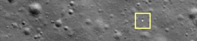
Shanmuga Subramanian, a space enthusiast who was well-known for having previously located India’s Vikram lander in 2019, carefully examined high-resolution photos taken by the Orbiter High Resolution Camera (OHRC) on Chandrayaan-2. The OHRC photos showed the crash location and scattered debris of the Resilience lander with an amazing resolution of 0.25 meters, the highest of any lunar orbiter. Subramanian detected unique patterns and bright reflections in the impact region, which were consistent with the appearance of spaceship fragments. Since contact was lost, this was the first visible confirmation that the lander had made a hard touchdown.
A clear impact site with debris strewn several meters from the primary crash site can be seen in the photos. The impact churned up regolith, or lunar dust and boulders, which is why the crash left a dark smear on the lunar surface with a faint bright halo surrounding it. The photographs have been extensively shared and commended for their clarity and scientific worth, even though ISRO has not yet formally released them.
International moon expeditions have already benefited from Chandrayaan-2’s imaging capability. Notably, Japan’s SLIM (Smart Lander for Investigating Moon) mission used orbiter data to assist in choosing the ultimate landing location.
According to ispace’s preliminary investigation, the lander’s laser rangefinder, which measures the distance to the lunar surface, malfunctioned, causing the accident. The lander was unable to decelerate sufficiently during its final descent due to delays in the instrument’s acquisition of reliable measurement information. Consequently, the surface was destroyed as Resilience struck it quickly.
The results from Chandrayaan-2 were confirmed by photographs taken of the crash site by NASA’s Lunar Reconnaissance Orbiter (LRO). The disturbance brought on by the lander’s impact is further confirmed by the LRO photos, which display a dark area with a light ring. The estimated distance between the crash scene and the planned landing spot was 2.4 kilometers.
The finding emphasizes how independent analysts and high-resolution lunar orbiters are becoming increasingly important in space exploration worldwide. The debris was successfully located by Chandrayaan-2, demonstrating the mission’s cutting-edge technological prowess and its contribution to global lunar science.
At a news conference on June 24, 2025, Ispace is expected to give a thorough report on the technical cause of the incident.
An important milestone in lunar reconnaissance and international space collaboration was reached when Chandrayaan-2’s orbiter, with the help of amateur astronomer Shanmuga Subramanian, identified the Resilience crash site.
The results highlight the value of high-resolution orbital imagery in solving the puzzles of space exploration failures and provide vital information for upcoming lunar missions.